
72625 posts
Hi Kengau64 and welcome to MySwissAlps!
Be sure to have a look at our Zermatt activities page here. It lists popular attractions as well as many hikes available in the area (including distance, difficulty etc).
Zermatt’s tourism page also lists Sunnegga, Rothorn, and Blauherd details as well.
https://www.myswissalps.com/sunneggarothorn
279 posts
Hi Ken.
The Hoernli path should be open by the time you are there, it’s definitely something worth doing. If you are taking the gondola to Schwarzsee and hiking from there, just be aware that it shuts at about 3 pm, so you have to be off the mountain early or you have a long walk back to town to deal with.
Cheers
Alan
72625 posts
Thanks for that info…also can someone tell me which trail this is at 1:46 of this videoyoutu.be/eeFm32Ej8wQ
Is it bike only?
Thanks
Ken
279 posts
Hi Ken,
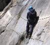
I haven’t hiked on that side of the valley, but looking at the map, it appears to be a gnarley part of a looping hike that leads to Trift, a popular hiking destination. Again, looking at the map, I’m suprised there are bikes on it at all because of how tight and twisty the path is and there is no lift to get you to the top. My guess is it is a hiking trail that the videographer wanted to include because it is spectacular.
The trail starts next to the Railway Station, goes through Spiss, doubles back at the 1821 M mark, crosses the rock bands and keeps climbing until you hit 2503 M, then continues slightly downhill to Trift before doubling back again and following the Triftbach back to town. I think it would be easier to do it in the opposite direction to the bikes because the first few legs starting at the Railway Station are quite steep.
This link shows that part of the map that covers the path to Trift
map.schweizmobil.ch/?lang=en&land=wanderlan d&route=all&bgLayer=pk &layers=Wanderland&sea son=summer&resolution= 2.5&E=2623208&N=109744 4
Cheers
Alan
72625 posts
Sounds good, Thanks, can’t wait!!
72625 posts
Did some more digging regarding that trail along the cliff, I found another bike video that mentions its on a unnamed trail from Findeln to Gourmetweg then to Zermatt…Does that sound right?
vimeo.com/30223690 at 8:58
279 posts
Hi Ken,
I stand corrected. It is definitely part of the Gourmetweg. I had to picture match it with Google Earth Pro to work it out, but you are correct. I have actually walked from the Gornergrat through Findeln to Zermatt and not seen this exact path. It just goes to show, it doesn’t matter how often you go to Zermatt (or Switzerland, come to that), there are always more corners to explore.
The signpost they shot past at the trail junction at 8:58 indicates it is a hiking path – nothing about bicycles, so you should be good to go. The link below is for Goole Earth at that point
http://www.google.com.au/maps /@46.0107985,7.761088, 2a,75y,275.57h,81.1t/d ata=!3m6!1e1!3m4!1spaH tUxs5rE2DQheZpkWRmA!2e 0!7i13312!8i6656
And here is the part with the fence and hand rail.
http://www.google.com.au/maps /@46.0132582,7.7549489 ,2a,75y,252.89h,78.99t /data=!3m6!1e1!3m4!1sW SVZgGcM2POBwg8WZHAx5Q! 2e0!7i13312!8i6656
You can zoom out of the picture to see the map.
Thanks for putting me straight
Have fun
Alan
72625 posts
No, thank you…glad you verified the spot. I was also looking at restaurants around there, Chez Vrony, and noticed someone had posted some pics on that section of trail as well.
Thanks Ken


