

The best Swiss hiking apps
Swisstopo and Switzerland Mobility are the best apps to use for hiking in Switzerland.
- Swisstopo is Switzerland’s official topography institution. It publishes paper maps, but also the swisstopo app. The app combines Switzerland’s official national maps with information about hiking, winter hiking, snowshoe hiking, cycling, and more.
- SwitzerlandMobility is specialized in outdoor activities in Switzerland. Its app shows Switzerland’s complete network of hiking trails. It includes a GPS function, plus information about public transport and accommodation along the routes. The “Plus” subscription allows you to use all maps without network coverage and to record your hikes and other tours.
Don’t forget to install a reliable weather forecast app too. Find our recommendations here.
The best Swiss paper hiking maps
Why use a paper map?
GPS devices and smartphone navigation apps are very handy tools. Annika and I use them ourselves and love them. But there are disadvantages too:
- With empty phone batteries, these digital maps are useless.
- The GPS function in the apps depends on the reception of satellite signals or phone networks. Coverage in Switzerland is good, but you may have no coverage in remote (mountain) areas.
- Unless your device has all maps stored on the device, you need an affordable data plan as well.
Paper maps always work. They are an ideal backup to technology, or even a perfect main navigation tool. And it’s fun to unfold a map and start preparing for your hikes. Paper maps can easily be reused for 10 years before you need a new one.
Which map to buy?
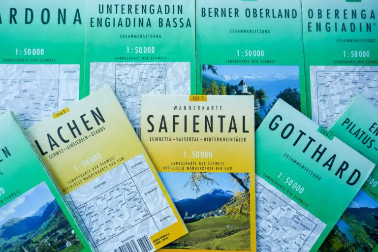
I recommend the 1:50,000 yellow hiking maps of the Swiss Federal Office of Topography.
This office publishes paper maps of various types and with varying scales:
- The main scales are 1:25,000, 1:33,333 (waterproof), and 1:50,000. In my experience, the 1:50,000 maps are detailed enough to find your way, and cover a large area with lots of hiking trails. The maps in scale 1:25,000 are extremely detailed but cover a smaller area.
- National maps have a green (1:50,000) or beige (1:25,000) cover, and each one has a 3- or 4-digit product number and a name, e.g. “2520 Jungfrau Region”.
- Hiking maps (1:50,000) have a yellow cover, and each one has a 3- or 4-digit product number plus the letter “T” and a name, e.g. “254T Interlaken”. These maps are basically the same as the all-purpose maps, but the signposted hiking trails are highlighted and they also show public transport stops.
We mostly use the 1:50,000 yellow hiking maps.
Where to buy maps?
Maps are for sale in Swiss bookstores and kiosks at larger train stations. Note that there are hundreds of maps and most stores won’t have all of them in stock. They usually only offer popular maps of the surrounding region.
You can buy the maps online as well: you’ll save on shopping time and can study them at home to prepare.
Buy hiking maps online
Recommended maps:
- 235T: 1:50,000 hiking map of northern Lake Lucerne
- 245T: 1:50,000 hiking map of southern Lake Lucerne
- 254T: 1:50,000 hiking map of the Interlaken area (Lake Thun, Lake Brienz, northern Jungfrau region)
- 264T: 1:50,000 hiking map of the southern Jungfrau Region and Aletsch glacier
- 262T: 1:50,000 hiking map of eastern Lake Geneva, Vevey, and Montreux
- 276T: 1:50,000 hiking map of Locarno and the Verzasca valley
- 286T: 1:50,000 hiking map of the Lake Lugano region
- 5013: 1:50,000 large all-purpose map of the Upper Engadine (St. Moritz, Pontresina, the Bernina Pass, and more)
Find prices at www.stanfords.co.uk, a maps and travel books retailer since 1853.
All maps:
- 1:25,000 all-purpose maps:
www.stanfords.co.uk/Switzerland-Swiss-Survey-25K-Topographic-Maps - 1:33,000 and 1:50,000 hiking maps:
www.stanfords.co.uk/Switzerland-Swiss-Survey-50K33K-Hiking-Editions-of-Topographic-Maps - 1:50,000 all-purpose maps:
www.stanfords.co.uk/Switzerland-Swiss-Survey-50K-Standard-Editions-of-Topographic-Maps
- www.swisstopo.ch: swisstopo app
- www.schweizmobil.ch: SwitzerlandMobility app
- www.swisstopo.ch: find the paper map for your region
- www.peakvisor.com: find the location and altitude of the Swiss mountains
