
7567 posts
<<” Is there a trail from Wengen down to Lauterbrunnen? Could you tell me if their are trials in the Lauterbrunnen Valley. Looking at GoogleEarth I can see a road that runs south in the valley toward Stechelburg and part way to Stechelburg there is a bridge across the river with a smaller road/trail heading back toward Lauterbrunnen. Are there by chance paths/trials along the road for walking/running/biking? “>>
There is a trail everywhere in Switzerland. Some years ago, I walked partway down from Wengen to Lauterbrunnen on a well-maintained trail. I did not think it was a trial.
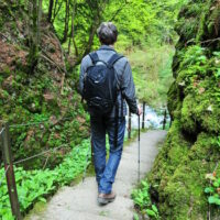
I don’t understand why you need trails beside the road on the floor of the LBV to Stechelberg. (Don’t know where Stechelburg is). That road is not a superhighway. You can run on it or walk on it or bike on with minimal concerns about traffic. What traffic there is goes slowly. Check the attached image file to get a sense of the road. At high resolution, you can see walkers on the road. Not so easy to see in this compressed image. Still, you can get the correct impression. It is a well-paved, not too wide, country road. Buses run on it, maybe once an hour.
Check these sites:
map.geo.admin.ch/?X= 190000.00&Y= 660000.00
wanderland.ch/en/ services/places/ort-0368.html
One can also run from Kleine Scheidegg down to ( or the reverse, up to K.S.from ) Grindelwald ( about a 1000 meter altitude change) or Wengen ( about an 800 meter altitude change.)
Either one will give heart, lungs, and legs some good exercise. Trails may have some loose gravel, ruts, or other reasons to be careful. A lot are on pved roads, however. Remember just how high you are. The trails are not difficult; I’ve seen wheelchairs , mountain bikers, and grandmothers on these trails.
if your granddaughter does not run in Denver at a mile high for conditioning, she may wish to consider the widely differing altitudes of these locations. Use the Swisstopo website.
15485 posts
The Lauterbrunnen valley is perfect for running on nearly flat terrain. There are two roads. Take the western one, which is a quiet country road, right along the Staubbach Fall. The eastern one is for traffic and too dangerous to run on.
7567 posts
Arno said: <<“The Lauterbrunnen valley is perfect for
running on nearly flat terrain. There are two roads. Take the western
one, which is a quiet country road, right along the Staubbach Fall. The
eastern one is for traffic and too dangerous to run on.”>>
Arno-
Thanks for correcting my unclear post.
That smaller road is clearly visible on SwissTopo
map.geo.admin.ch/? X=161532.40& Y=636514.56
I believe that it is the one visible in the image that I posted, too. I have walked it a couple of times, and, as you say, traffic is light.

7135 posts
As far as I can tell, it’s indeed the road that can be seen in the middle of the lower half of your picture! In the last link you posted, it’s the white road going south, not the yellow one, which is main road.

29 posts
Agree the small road on the west appears to be a good place to run. Appreciate your help…now any ideas on Zermatt? Think it offers fewer choices? Thanks again.
7567 posts
<<“Agree the small road on the west appears to be a good place to run.”>>
Once she is there, she may consider other trails. That one looks like a sure bet. Others are less certain.
I have seen runners on trails where I was wearing hiking boots and felt that I needed a hiking staff.
The valley floor is at about 1/2 mile above sea level (796 to 910 M.u.M.). If she goes up to Wengen, she’ll be at about I mile high, and Männlichen is at about 2200 meters ( approx 1.35 miles.)
15485 posts
There are some options in Zermatt too. For example, this town walk is nearly flat. Trails out of town towards Zmutt and Zum See are, to Swiss standards, pretty flat. Beyond that one encounters some serious slopes which are wonderful hiking terrain. All of the area is car free, so no concerns there.


