Engstligenalp-Engstligen Falls: the facts
- Hiking time: 1h30
- Difficulty: difficult
- Elevation: 1393 – 1968 m
- Distance: 2.9 km
- Terrain: meadows, forests and waterfalls
- Region: Adelboden in the Engstligen Valley (Bernese Oberland)
About the trail
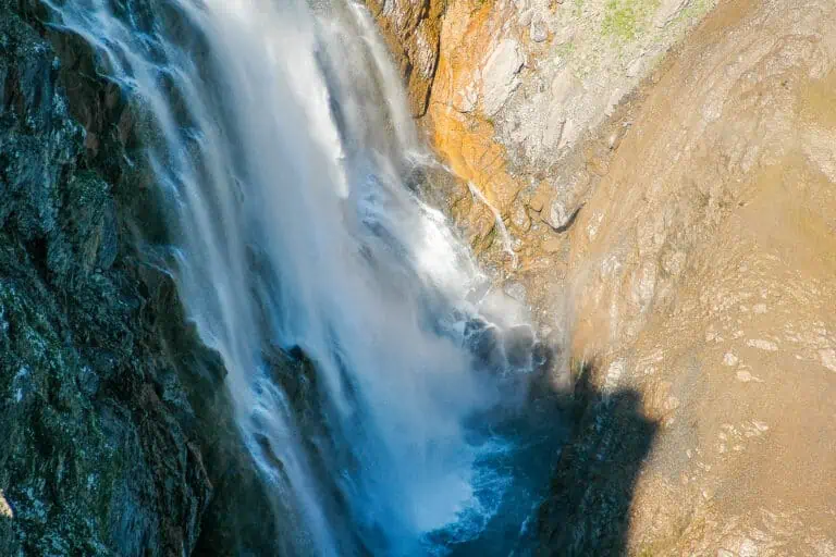
From the valley at Unter dem Birg you can already see the Engstligen Falls and the steep surrounding rock walls. It seems impossible that there’s a footpath leading down from Engstligenalp along the falls, but there is. The path is not dangerous, although walking carefully is recommended; many sections consist of rocks and loose stones.
At the beginning of the route, you will have a nice view of the village of Adelboden. Then the path continues steeply downwards through a rocky landscape and flowery meadows, and soon you will come face to face with the beautiful Engstligen Falls. You will pass impressive rock walls and then reach Unter dem Birg through the forest.
An alternative is to do the trail uphill; this takes about 15 minutes more.
Directions and map
How to reach Engstligenalp
You will reach Engstligenalp by cable car from Unter dem Birg near Adelboden. There is a parking lot at Unter dem Birg, which can also be reached by bus from Adelboden. Adelboden can be reached by bus from Frutigen.
Hiking directions
Follow the signs “Unter dem Birg/Wasserfall”, and after the fall to “Unter dem Birg”. At the beginning of the route, just after you have passed a bridge over the river, the path splits up into a broad path (on the left) and a narrow one (on the right). Turn into the broad path on the left.
Trail Engstlenalp-Unter dem Brig (Adelboden) on a map

Promotions 

Various multi-day packages for guided and self-guided trips to Switzerland. The offerings change regularly. Packages including surrounding countries are available too.
Our extensive Bernese Oberland guide

Bernese Oberland
Other blog posts you may like
Hike Täsch-Zermatt

Hike First-Grosse Scheidegg