InfoMySwissAlps.com includes display ads, non-commercial links, and commercial links to Stay22 and other trusted partners.

Zurich panoramic walk: from Uetliberg to Felsenegg Copy link to clipboard

Get a bird’s eye view of Zurich and Lake Zurich on the lovely walk from Uto Kulm (the top of the Uetliberg mountain) to Felsenegg.

View to Felsenegg from Uetliberg, Zurich

The easy way to plan your Switzerland trip

➤ Let the experts handle the research and bookings for you. We design a unique, independent journey based on your wishes. Save time and avoid common mistakes. See how it works

Uetliberg-Felsenegg: the facts

  • Hiking time: 1h45
  • Difficulty: easy
  • Elevation: 790 – 871 m
  • Distance: 6.0 km
  • Terrain: meadows, forests
  • Region: surroundings of Zurich

About this trail

The trail starts at the top of the Uetliberg (Zurich‘s local mountain). The mountain features several hiking and walking trails. One of the most scenic trails is the one to Felsenegg with its restaurant and gondola. The gondola can then take you down to Adliswil to return to Zurich by train.

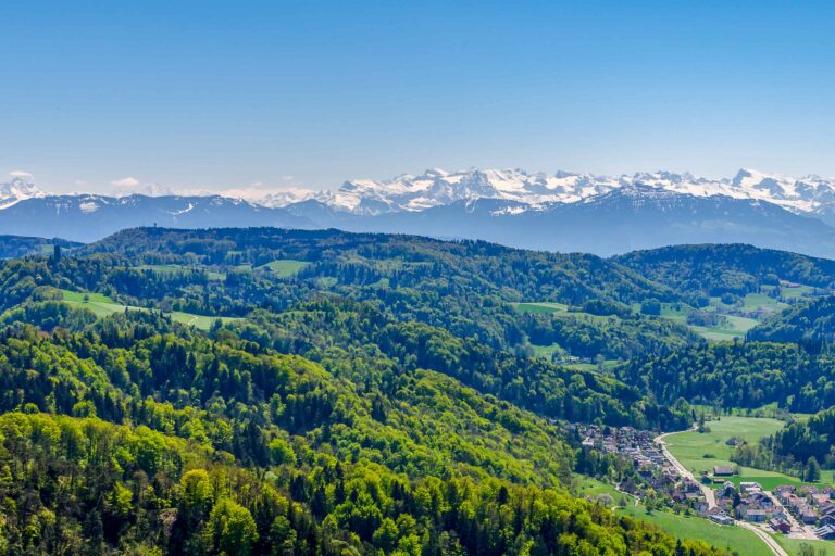
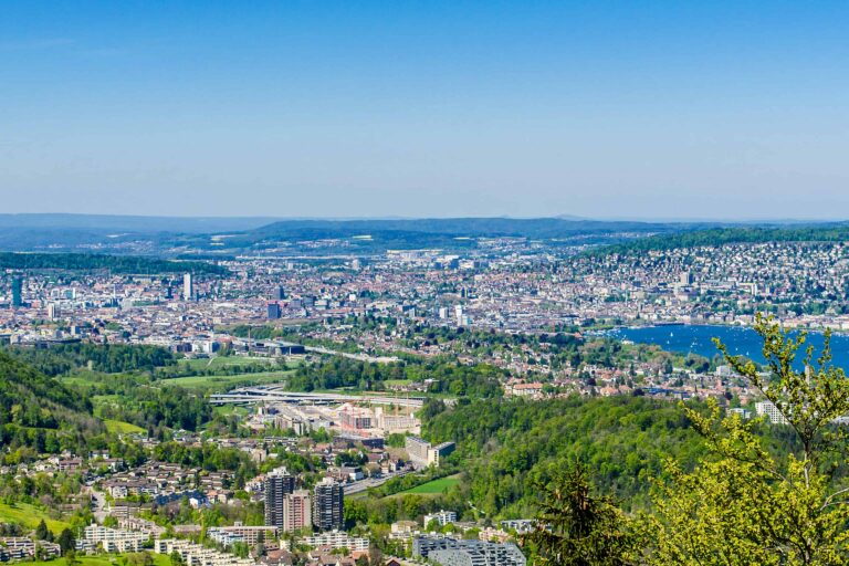
The wide trail is flat and easy with small elevation gains and descents – perfect for families with baby strollers. There are shady forested areas as well as open fields along your path. Featuring amazing views of the city of Zurich from Uetliberg, as well as Lake Zurich, as the trail follows along the lake at 800 meters.

This trail is also known as Planetenweg (“The path of the planets”). The path features a model of our solar system at a scale of 1:1 billion (1 meter equals 1 million kilometers). You will find the model of the Sun shortly after starting the hike from Üetliberg – keep your eyes peeled for Pluto at the end as it is quite small!

If you prefer to hike to the top of Uetliberg (871 meters) you can take a tram or bus to either ‘Albisgütli’ or ‘Triemli’ and start your hike. It takes about an hour either way on a well-maintained, winding switchback trail to the top. Then continue to Felsenegg as described above.

Directions and map

How to reach Uetliberg

The top of Uetliberg mountain can be reached by train or hiking only. Trains run regularly from Zurich HB (main station) and take about 30 minutes.

How to get back from Felsenegg

At Felsenegg you can take a gondola down to Adliswil. Then walk down the hill along a residential street to reach the train station in about 5 minutes. Take a train back to Zurich HB (about 25 minutes).

The hiking route

Follow the signs to Felsenegg until you reach the cable car station.

Map of the Uetliberg-Felsenegg trail

Maps are available to members only
Check out all the benefits members have access to
Create a free account
Map
Our insider tips for the city of Zurich Copy link to clipboard
Zurich and its lake seen from Uetliberg

Zurich

Zurich is the largest city in Switzerland. There is a lot to see and do, including boat trips, museums, luxury …
Other blog posts you may like Copy link to clipboard
Local train between Täsch and Zermatt

Hike Täsch-Zermatt

Walk along the railroad in the Matter Valley to the famous mountain resort Zermatt.
Bench with view of Schreckhorn and Grindelwald, between First and Grosse Scheidegg

Hike First-Grosse Scheidegg

Easy walk across alpine meadows with great views of the Jungfrau massif. You can continue by bus or on foot …
Reflection of Schreckhorn and Finsteraarhorn in Bachalpsee

Hike First-Bachsee

Popular, easy trail to a beautiful mountain lake with reflections of the Schreckhorn and other mountains above Grindelwald.
Church in Kander valley near Kandersteg

Hike Kandersteg-Frutigen

Enjoy the Kander Valley and learn about the Lötschberg Mountain Railway at the same time.
Rosenlaui valley towards Grindelwald, Wetterhorn and Eiger from Hasliberg

Hike Grosse Scheidegg-Meiringen

Admire the great scenery during this hike between the valleys of Grindelwald and Meiringen. It starts just above the tree …
Rhätische Bahn train between Preda and Bergün

Hike Preda-Bergün

Watch the famous red trains of the Albula train line and the amazing landscape.
Rock formation at Schynige Platte, Bernese Oberland

Hike Schynige Platte

Beautiful circular panorama trail with alpine flowers and views of the Jungfrau.
Panorama views over the Upper Rhone valley from Fiescheralp

Hike Bettmerhorn-Märjelensee-Fiescheralp

Extraordinary trail along the Aletsch Glacier with many beautiful views of the Bernese and Valaisian Alps.
The Engstligen Falls at Engstligenalp, Adelboden, Bernese Oberland

Hike Engstligenalp-Engstligen waterfall

Impressive short hike in the Bernese Oberland: from Engstligenalp via the falls back down into the Adelboden Valley.
Chalets and meadows with snow at Furi, Zermatt

Hike Furi-Zermatt

Make this short, very scenic walk from Furi to Zermatt. You can combine this with a trip up to Matterhorn …

About MySwissAlps

We’re Arno & Annika: passionate, frequent Switzerland travelers. We help you plan your trip, or we plan it for you. MySwissAlps was founded in 2002.

Want us to plan your trip?

The easiest way to plan your trip is to let us handle the itinerary design and bookings for you. We design a unique, independent journey based on your wishes.

Just need some help planning your trip?

Let us help you personally, or post your questions to our forum.

Annika
Page author: AnnikaSince early childhood I've been visiting Switzerland during my holidays and I just fell in love with the country. I spent many summers in the Bernese Oberland, which still feels like my second home, and then started to explore other areas. Traveling, hiking and photographing in the Swiss Alps are my absolute favorite activities.