InfoMySwissAlps.com includes display ads, non-commercial links, and commercial links to Stay22 and other trusted partners.

BLS Südrampe trail: images and information

Short summary – read this first

A traveler named Slowpoke shares their favorite hiking trail from Hohtenn to Ausserberg, emphasizing its accessibility by train and good weather, especially in summer. They discuss the trail's challenges, historical water channels, and nearby accommodations, looking for tips on the best experiences along the route.

Key takeaways:
  • The Swiss Travel Pass offers flexibility for train travel, allowing easy access to the trail from various starting points.
  • Plan your visit during early spring or late fall for a pleasant hike, as summer can get hot and dry.
  • Check the trail status before visiting, as certain sections may be closed or under maintenance, especially in early spring.
➤ For an instant mobile ticket, with easy online cancellation, get your Swiss rail passes from the official SBB tourist webshop.
InfoAI-generated summary. Details may be outdated. Check with our travel experts to be 100% sure.
  • Anonymous
    Inactive
    83570 posts
    26 February 2016 at 19:19:58 #808495

    Occasionally we discuss the trail named in the title.

    There are a lot of links on line, but some of the best are only in German.

    There is a mention here in My Swiss Alps:

    http://www.myswissalps.com/hi king/hohtenn-lalden/route

    I have hiked (or walked) the section from Hohtenn to Ausserberg many times, and onward to Lalden at least once.

    Because the Rhone alley is often dry and sunny when the rest of Switzerland is having disagreeable weather, this trail is a useful resource, easily accessible by train. It is hot and dry in the Summer months.

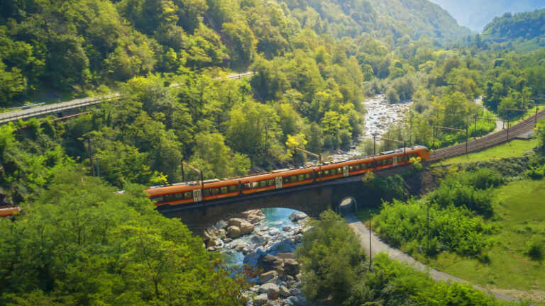
    Since the new “basis” tunnel from nerar Frütigen to Visp opened, there is local train service over the very scenic old route from Bern to Brig via Kandersteg, on the train named “Lötschberger” or Lötschberg Express.’

    Here are a few photos from along the trail, starting at Hohtenn Station.

    More in another post

    Slowpoke

    🇨🇭 The official SBB tourist webshop
    ✓ Discounts for passholders ✓ Instant mobile e-Ticket ✓ Free cancellation option
    🎁 Promotion: Buy your pass and get a free CHF 100 itinerary review! See details ►
    Swiss Travel Pass Unlimited travel

    Swiss Travel Pass

    Unlimited train, bus, & boat travel across Switzerland.

    Mountain excursions With discounts

    Mountain excursions

    Official e-Tickets with pass holder discounts. Skip the ticket counter.

    Regional passes Unlimited travel

    Regional passes

    Unlimited travel in the Berner Oberland, Jungfrau Region or Lucerne Region.

  • User
    Inactive
    83570 posts
    Reply 1 of 7 • 26 February 2016 at 19:22:34 #848760

    More photos of the BLS Südrampe Trail

    Swiss Rail Pass Promotion

    ➤ Buy a rail pass and get a free Expert Itinerary Review. Works for all travel dates, 1st and 2nd class. See how it works

    User
    Inactive
    83570 posts
    Reply 2 of 7 • 26 February 2016 at 19:24:27 #848761

    third set of photos of the BLS Südrampe trail

    User
    Inactive
    83570 posts
    Reply 3 of 7 • 26 February 2016 at 22:03:11 #848762

    4th set of photos of the BLS Südrampe trail.

    The pictures of debris (#29) and trail maintenance were taken on a walk in the spring, just before Easter. The trail was not officially open , but was passable, with care. It opens at Easter time, if I recall correctly.

    The trail sign at Station Hohtenn in image number 3 shows that the trail was closed. There were several walkers on it anyway… By the time thatthe trail was fully open, the debris would be removed, and the handrails installed at appropriate locations.

    In spite of the fact that the trail was “closed” the beer garden (Image #21) above Raron was open, and serving hikes as well as people who came up there by car. There is a road up the side wall of the valley to that point.

    The water channels (bisse) are a centuries old mechanism for bringing water from snow melt to the dry farms on the valley walls. There are a set of traditions and customs going back about 1,000 years associated with the bisse.

    In the old days, the water was sometimes carried across cliff faces on hollowed out logs suspended on wooden posts inserted into holes drilled in the cliff faces.

    Today, mostly steel pipes or tunnels.

    A fascinating book with pictures of the maintenance workers walking on those traverses across the cliff faces is :

    Au Pays des Bisses, by Auguste Vautier, Editions Ketty and Alexandre, 1063 Chapelle sur Moudon, Switzerland, originally published in 1928 and 1939 and re-issued in 1993, by an organization of the canton ( Valais/Wallis) . ISBN 2-88114-052-1

    Slowpoke

    User
    Inactive
    83570 posts
    Reply 4 of 7 • 26 February 2016 at 22:18:23 #848763

    5th set of photos of the BLS Südrampe Trail

    🇨🇭 The official SBB tourist webshop
    ✓ Discounts for passholders ✓ Instant mobile e-Ticket ✓ Free cancellation option
    🎁 Promotion: Buy your pass and get a free CHF 100 itinerary review! See details ►
    Swiss Travel Pass Unlimited travel

    Swiss Travel Pass

    Unlimited train, bus, & boat travel across Switzerland.

    Mountain excursions With discounts

    Mountain excursions

    Official e-Tickets with pass holder discounts. Skip the ticket counter.

    Regional passes Unlimited travel

    Regional passes

    Unlimited travel in the Berner Oberland, Jungfrau Region or Lucerne Region.
    User
    Inactive
    83570 posts
    Reply 5 of 7 • 26 February 2016 at 22:26:36 #848764

    6th set of photos of the BLS Südrampe Trail

    I usually start at Hohtenn (where I get off the train) and stop at Ausserberg, to catch a train. From there to Brig or to Spiez and Bern.

    The Hotel Sonnenhalde at Ausserberg is a pleasant place to stay, but it is a bit of a climb up from Ausserberg Station.

    Here is a link to Swisstopo for the site of the hike.

    map.geo.admin.ch/?topic=swisstopo&lang=e n&bgLayer=ch.swisstopo .pixelkarte-farbe&layers=ch.swisst opo.swissimage-product&X=129620.00&Y= 627620.00&zoom=6&layer s_visibility=false

    Slowpoke

    Arno
    Moderator
    15772 posts
    Reply 6 of 7 • 29 February 2016 at 13:38:29 #848765

    Great information and pictures, thanks! The images also show how much work it is to keep hiking trails like this accessible. The Bietschtal bridge is still wonderful, even without the long international trains that now use the tunnel.

    User
    Inactive
    83570 posts
    Reply 7 of 7 • 29 February 2016 at 16:33:55 #848766

    <<“The images also show how much work it is to keep hiking trails like this accessible.”>>

    Hi Arno –

    Thanks. Toward the latter part of that section where the trail follows the bisse, approaching Ausserberg, a good part of the work is also to keep the bisse functioning. So, the trail benefits from centuries of maintenance on the bisse.

    We once walked some bisse trails from Haut Nendaz back in to the valley, and back out to Veysonnaz. One of the bisses on the way out was no longer maintained. Not functioning. The deterioration showed the accumulatiion of years of neglect, and it made clear just how much work would have been needed to keep it functioning.

    The trail near the Luogelkin and also at both ends of the Bietchstal bridge (where there are short tunnels on the trail) runs on the roadbed of what was once a narrow gauge railway, used to bring workers and supplies in and out.

    The beer garden changed hands a few years ago.

    It is a lot less simple now, and the storage cave in the wall has been made into a pretty dining room. Unfortunately, the food, although perhaps with a better presentation, and still quite acceptable, is not as good. No more potato salad, and the Rösti are loaded with rather strong onions and not well cooked. I have learned to say ” mit keinen Zwiebeln”.

    However, the most important functions – providing a cold beer on a hot day halfway along the hike in the sun, and a toilet – are still good. The sun can be very warm along that wall of the Rhonetal, which makes it a great early Spring or late Fall walk. Hot and dry in the warmer months Very little rain, hence the bisses (die Wasserleitungen) to support farming.

    Slowpoke

  • The thread ‘BLS Südrampe trail: images and information’ is closed to new replies.

About MySwissAlps

We’re Arno & Annika: passionate, frequent Switzerland travelers. We help you plan your trip, or we plan it for you. MySwissAlps was founded in 2002.

Want us to plan your trip?

The easiest way to plan your trip is to let us handle the itinerary design and bookings for you. We design a unique, independent journey based on your wishes.

Just need some help planning your trip?

Ask your questions to us personally or to the forum. Or see how we plan Swiss holidays for real travelers, and discover how to avoid mistakes.