

Tips about Wengen and the Jungfrau region by Kim
-
15 December 2017 at 18:12:13 #840481
September, perfect! Typically the weather is the best of the year and the summer crowds have gone home.
We are taking all of our kids and grandkids this year and, due to their schedules, we will be going in July.
15 January 2018 at 23:43:17 #840482Hi Kim, thanks for all the great info. I’ll be visiting for the first time in September. Is there any reason you chose Wengen over Murren as your home base?
16 January 2018 at 16:01:58 #840483Both are beautiful places, which to choose is a matter of personal preference and you can’t go wrong either way. Everyone has their opinions, following are mine on the three bases (Wengen, Mürren, Lauterbrunnen) most consider when visiting the region:
Lauterbrunnen is a very small village down deep in the valley with imposing cliffs above. Therefore it doesn’t get as much daylight as the villages up the mountains do. There is quite a bit of car and bus traffic through the little village and limited selections of restaurants and food stores. During the high summer seasons (July and August) there is a “college student backpacking around Europe” vibe. There is not much there in the way of sightseeing/views, other than the glorious walk down the valley floor (which can also easily be done from Wengen or Mürren). The positives are that there is a fairly major train station there (although Wengen and Mürren are only 15 and 18 mins, respectively, up the mountainsides) and lodging is less expensive (there’s a reason).
Getting up into a car-free village gives one a much more “old Switzerland” feel. You can’t go wrong with either Mürren or Wengen. We prefer Wengen because we like the views better from there (jaw-dropping), it is slightly larger therefore has more amenities (food stores, restaurants, shopping), is easier to get in and out of so is better as a base, and we think it has more of the quintessential Swiss mountain village “vibe” than does Mürren.
17 January 2018 at 0:00:25 #840484Great job!
1 March 2018 at 19:52:00 #840485Thank you Kim for a great document. I and my wife are planning our first trip to the Swiss Alps this July and we were not sure how to make the most of it in the five full days we will be there. This was a big help for us to decide where to set up base and answers most of the FAQs. I have already saved the document on my laptop to take along. Will post pictures upon return.
Thank you.
11 March 2018 at 3:27:51 #840486Hi Kim
Alpenrose666 guided me to the page with your pdf documents. I would like to join the chorus singing “Thank you” for your effort and generosity.
We are planning to tour Switzerland from 23 July to 5 Aug 2018. We won’t be hiking so much, however, we will attempt to do shorter walks.
12 March 2018 at 20:05:35 #840487Aloha Kim,
After discovering MySwissAlps online in preparation for a September hiking trip 2018, with my wife and another couple; I was elated to read your posts for all the time you’ve spent in Switzerland and the details of your experiences you chose to share with the global web community. I will be doing the walkers Haute Route for the first two weeks, then will be joined by the others for 5 days in Zermatt, 7 days in Wengen, 2 days on the shores of Lake Brienze and perhaps a day in Lucerne. I must admit, I am somewhat envious of your adventurous lifestyle. I can only manage one or two trips a year and retirement is not near, even though we are in our 60’s and perhaps should be. Anyway, I wanted to reach out to you, since I can resonate with your posts and perhaps get a concise list of must-do hikes to make the most of our time in both locations as if we were dear friends already and you wanted us to walk away with having done the best of the best. We are all in good fitness and have hiked throughout the Dolomites for many years now.
Mahalo Nui Loa,
Rick and Nancy; Kailua, Hawaii
13 March 2018 at 16:48:13 #840488Hello Rick and Nancy and welcome to the forums!
Sounds like a marvelous trip and you have chosen the best month of all. Typically the weather is quite fine and the summer crowds have gone home.
The majority of my experience is in the Bernese Oberland. I have been to Zermatt twice (most recently maybe 10 years ago) and haven’t returned as I prefer the lushness of the BO to the starkness of the Zermatt area. I also prefer Wengen over Zermatt village itself. Purely personal preference.
For your seven days in Wengen I suggest (if you have not done so already) that you download the three PDFs at
http://www.myswissalps.com/fo rum/topic/tips-about-wengen-and-the-jungfrau-region-by-kim. This will give you descriptions of many many hikes in the area and you can pick and choose what suits you at the time.
For your two days on Lake Brienzersee I would, of course, recommend a boat ride and perhaps a visit to Ballenberg Open Air Museum. It is totally delightful. A trip up the Rothorn on the steam train is quite breathtaking. Or simply strolls through Brienz, visiting the little shops and woodworker spots. Since two nights in one base = only one day in that base you won’t have time for too much more unless you leave Wengen earlier in the day to manage a half day or so at Brienz.
For one day in Lucerne I recommend a self guided walking tour. You can pick up maps and info at the tourist office at the train station.
13 March 2018 at 17:54:19 #840489<<“A trip up the Rothorn on the steam train is quite breathtaking. Or simply strolls through Brienz, visiting the little shops and woodworker spots.”>>
Hi Kim-
One of our favorite routes in the area was to stay in Brienz at the Weisses Kreuz, right at the base of the Brienzer Rothorn Bahn, ride up, walk to Schönbüel, get a bite, and ride the two stages of lifts down to Lungern. Short uphill to the Bahnhof, and train back to Brienz.
Today, the Weisses Kreuz, although has been rescued from the unfortunate Austrian owners to whom Frau Müller sold it quite a few years ago, and now is owned by the owners of the Briezerbürli hotel, has not resumed its former excellence. It seems to be quite OK these days, but not a place that I’d make a special effort to reach. Really really convenient.
The real problem is, that as far as I know, the upper stage of the lifts from Schönbüel to Lungern does not run anymore, which would make a long steep descent. And, I think that the restaurant at Schönbüel may not have stayed open. However, there are periodic attempts to revive it.
I’ll ask a friend in Switzerland who used to walk that route with us for the current status.
If it is accessible, it is a glorious ridge walk, with the ride up behind or ahead of steam power is really nice.
Slowpoke
13 March 2018 at 18:26:48 #840490Aloha Everyone,
Kim’s detail on the Bernese Oberland region is truely remarkable and informative. What a kind and giving member of this hiking community and for humantiy too.
Since we will be spending time; 5 days, in Zermatt also, does anyone have similar intel and hiking recommendations and such for the area?
Mahalo Nui Loa,
Rick and Nancy; Kailua, Hawaii
13 March 2018 at 20:05:15 #840491<<“Since we will be spending time; 5 days, in Zermatt also, does anyone
have similar intel and hiking recommendations and such for the area?”>>
Here’s a start:
http://www.myswissalps.com/ze rmatt
There are various useful maps for all kinds of hikers in Switzerland.
The most comprehensive and detailed one is the map from the Federal Land Office- Swiss Topo:
That one has the hiking trails turned on, with the normal color conventions:
http://www.alpenwild.com/stat icpage/trail-signs-in-the-swiss-alps/
Switzerland Mobility has a lot of information, with many useful details along the named National Routes.
I find it somewhat difficult to use.
You can start here:
Zoom in a bit on the map. The heavy green lines have detailed information available. Click on one…wait a moment or two for a window to open. It shows trail names. If it says “no information” you are not on one of the heavy green lines=named routes. Click on one of the names. A window opens on the left. read it, then click on “Directions.”
The window(page, actually) that opens has lots of links,, including accommodation, altitude profile, etc.
Here is an example:
http://www.schweizmobil.ch/en /hiking-in-switzerland/routes/rou te/etappe-01663.html
You can also use the search function. For me, it works best by entering either a route name or a place name and then working back on the trails.
There are also maps and lists for National Routes, Regional Routes, Local Routes…….
A simpler, less detailed and somewhat less useful (no altitudes) map is helpful for overviews, searching by place name, restaurant name, etc., and shows rail lines very very clearly at zoom level 32.
Try the menus under Points of Interest, Traffic. You can turn on icons for stations. Mouse over an icon and get a simple near time timetable.
map.search.ch/Zermatt?pos=625312,96400&z=32& poi=default
The SBB timetable is extremely useful:
http://www.myswissalps.com/ti metable
Since this discussion is moving off topic (KIm’s thread) it would be helpful if you would start a new thread of your own. Then, others can post about your itinerary, etc.
Slowpoke
14 March 2018 at 10:01:03 #840492Adding to my post about the route from Schönbüel to Lungern,
this seems to be the latest:
http://www.wanderparadies.ch/ wandern/mittel/h%C3%B6 henweg-turren-brienzer-rothorn/
In German, and describing the route in the other direction; It seems that the lift beween Schönbüel and Türren is not in service.
That means a 450 meter descent on foot ( or ascent if you go towards the Brienzer Rothorn). The trail is a “yellow” trail, so it is of good quality and does not require special gear.
Slowpoke
14 March 2018 at 14:10:49 #840493Regarding the stretch between Turren and Schoenbuhl, I believe the lift between is no longer operating. It would be a large addition if one wanted to descend by foot downward to Turren.
Fredch
14 March 2018 at 16:00:57 #840494I’ll be spending 3 nights in Lucerne and 3 nights in Murren in September. After reading through this and other sites I am seriously thinking of changing my reservations to Wengen. It sounds like Wengen is just a scenic but a better location for day trips. Does anyone here have ideas for my must-dos for my 3 days? My wife has two new knees so hiking will have to be kept to minimum and certainly very easy trails. Thanks for all the great info here!
14 March 2018 at 16:30:30 #840495Hi bespo77-
<<“Does anyone here have ideas for my must-dos for my 3 days? My wife has two new knees so hiking will have to be kept to minimum and certainly very easy trails. Thanks for all the great info here!
“>>
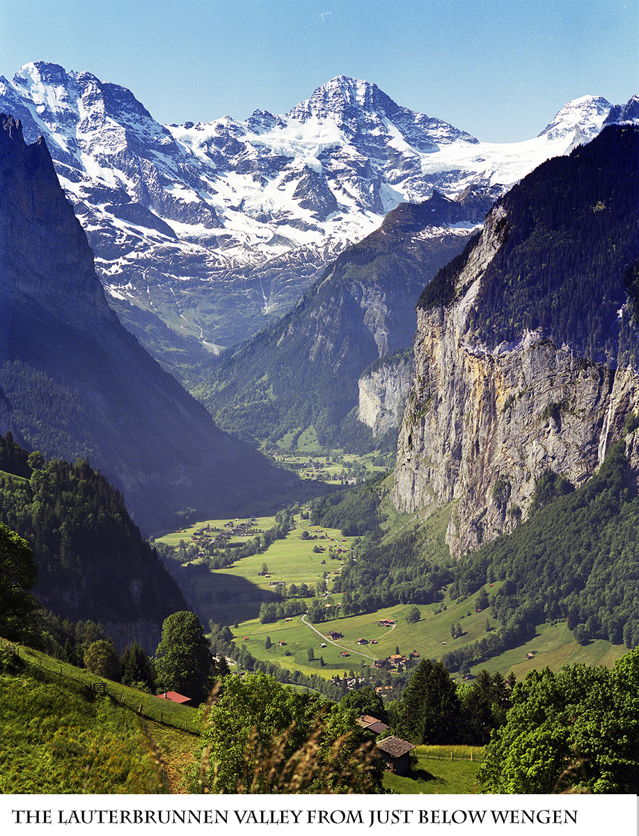
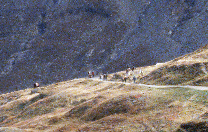
Both Männlichen and Mürren have good access to walks, and hikes. I like Wengen, in part because I think the views are better, but each person has there own preferences. The eay, level walk walk along the Valley floor along the bus route (partially visible in the attached image of the LBV) is easily accessible from either location.
Follow the links on this page:
http://www.myswissalps.com/be rneseoberland
Did you read Kim’s reports? Lots of information there.
Stuff on hiking, too.
My favorite easy walk is the walk from Männlichen to Kleine Scheidegg:
http://www.myswissalps.com/hi king/maennlichen-kleinescheidegg
So easy it is nicknamed “The Grannies’ Walk.”
Best to do it in the direction noted so you can see and “feel” the Eiger grow over you as you approach it.
This one, near Mürren is easy, too.
http://www.myswissalps.com/hi king/gruetschalp-muerren
My concern with it is that the easy way- gently downhill – has you facing away from the Jungfrau Massif. So, I always walk it in the mildly uphill direction – toward Mürren – so I can look toward the Jungfrau, etc., without having to stop and turn my head constantly. Helpful if you are looking for good pictures.
Slowpoke
Attachments:29 June 2018 at 4:39:51 #840497Hi Ann, and welcome to MySwissAlps!
>> I am a member but I can not locate Kim’s doc
They are attached to the first post (by Arno) on the first page of this thread:
http://www.myswissalps.com/fo rum/topic/tips-about-wengen-and-the-jungfrau-region-by-kim
Alpenrose
29 June 2018 at 19:38:19 #840498Hi Anne-
<<“I am a member but I can not locate Kim’s doc”>>
You are not the only one. I had trouble with the new search function for this one, and, after I found it, I bookmarked it.
Slowpoke
22 July 2018 at 18:22:27 #840499Wow, this is fantastic Kim. Thanks for your efforts in putting together this very detailed and helpful document. A lot of information you don’t find in tour guide books.
22 July 2018 at 22:39:17 #840500This is essentially a heartfelt thank-you note to Kim. Two friends and I returned from Switzerland earlier this month, and we spent a glorious 5 days hiking the Berner Oberland based out of a chalet in Wengen. We planned our trip and many of our walks heavily based on Kim’s PDF guide, which as others have noted here is far more detailed and useful than what you can find in official guidebooks. Some highlights: the rosti and salad and apfelkuchen at the Kleine Scheidegg train station restaurant, the day hike from Schynige Platte to First, and the view from the top of the Schilthorn, which we agree is better value than Jungfraujoch.
Kim, after a few days we started to talk about you and your recommendations as if you were the fourth member of our party… “Kim says we should do X,” or “Kim thinks Y is better than Z”, etc. Thanks for making our trip as seamless and memorable as it turned out to be!
Grace


- The thread ‘Tips about Wengen and the Jungfrau region by Kim’ is closed to new replies.


