 Main towns:
  Recommended season: early January to late February, early April to late October and late December
What to do in the Valais 
The best things to do in the Valais
If your time in this large canton is limited, we think these are must-do's:
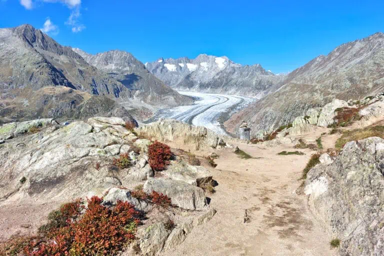
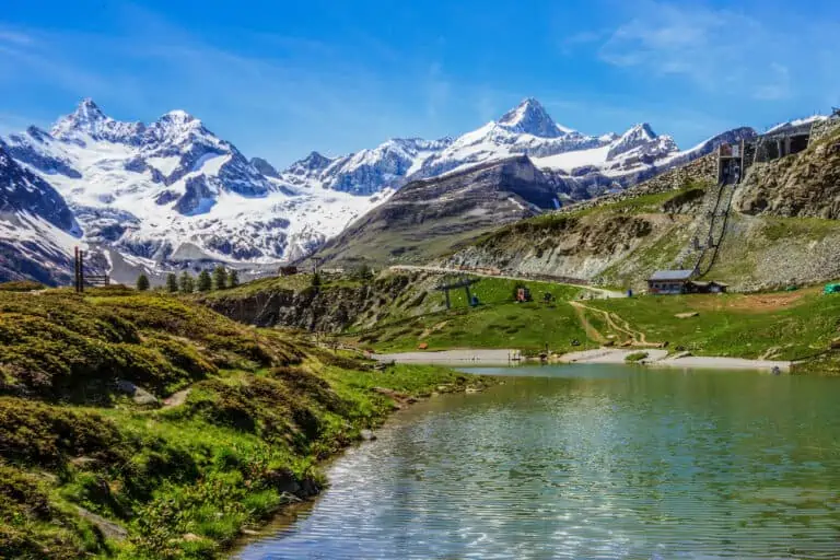
- Visit at least one mountain top. This can be one of the many options near Zermatt or Saas-Fee, but also one of the viewpoints near the Aletsch Glacier.
- Make a hike. Even if it's a simple valley hike, such as the valley trail from Täsch to Zermatt, we're sure you'll appreciate the beauty of the Valais while walking.
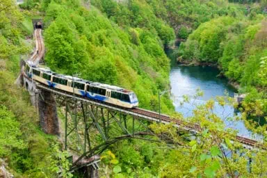
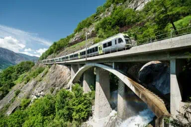
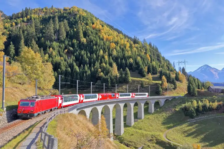
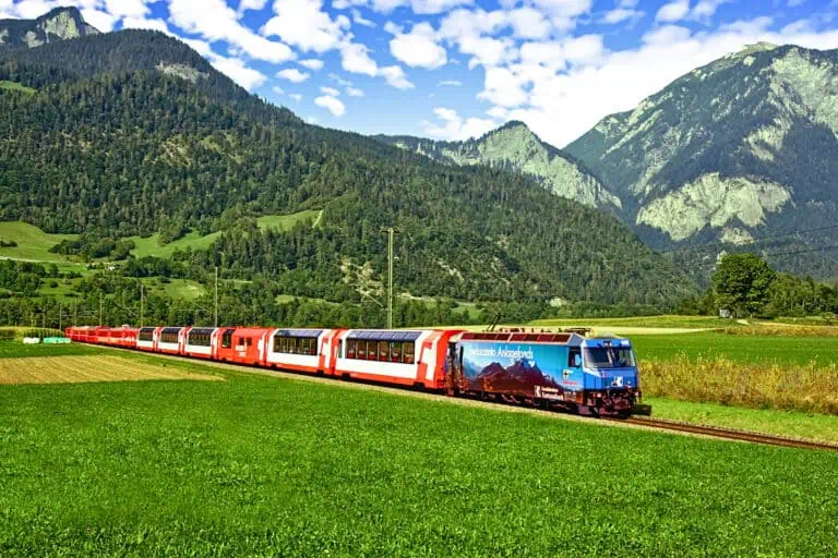
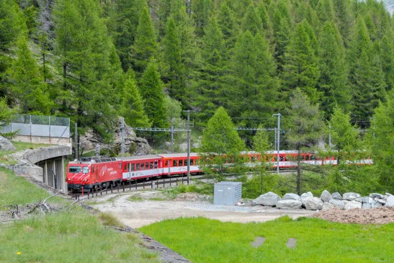
Scenic train rides in the Valais
Many train rides in the Valais are beautiful. Our favorites are:
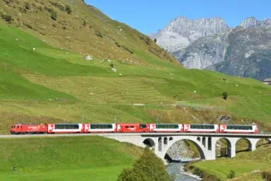
- The Lötschberg Mountain Railway between the Bernese Oberland and the Valais.
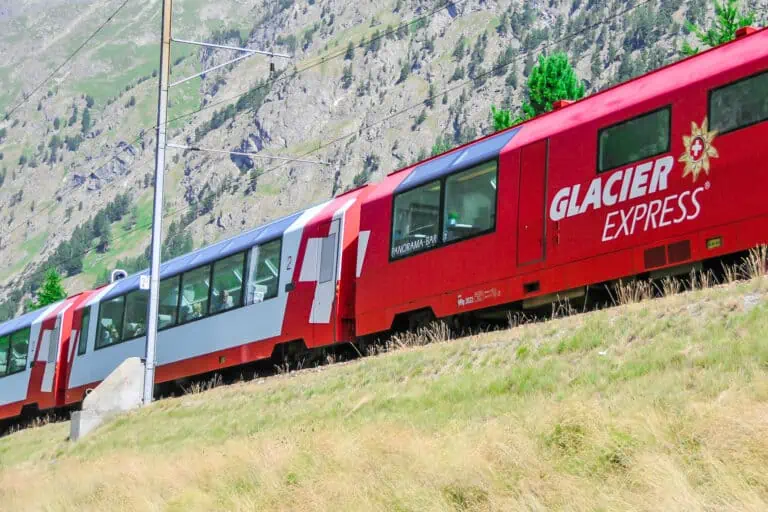
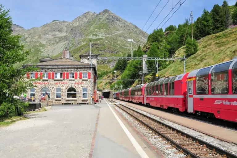
- The western part of the Glacier Express route, from Zermatt to Oberwald in the Upper Rhone Valley, or further to Andermatt. If you don't plan on doing the full Glacier Express ride, you can use normal regional trains too.
- The ride to Zermatt through the spectacular Matter Valley.
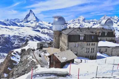
- The cogwheel train to Gornergrat.
Our favorite hikes in the Valais
We've been doing lots of hikes in the Valais and loved pretty much all of them. But if we had to pick our favorites, these would be:
- The long hike down from Bettmerhorn to Fiescheralp, along the Aletsch Glacier and the small mountain lake Märjelensee.
- The simple, but very scenic route from Fiescheralp to Riederalp with panoramic mountain views.
- The educational railway hiking trail between Hohtenn and Lalden.
- The easy roundabout hike at the Moosalp plateau.
- The routes from Riffelalp to Sunnegga and from Rotenboden to Riffelalp above Zermatt.
- Trails in the regional nature park Pfyn-Finges east of Sierre/Siders.
Day trips into Italy
Depending on where you're located, you may be able to take a short trip into northern Italy. Find suggestions in our travel guide Italy-Switzerland.
Travel info and map
Where exactly is the Valais?
The Valais is a large canton and holiday region in southern Switzerland. It borders the canton of Vaud in the west, the Bernese Oberland in the north, and small bits of Central Switzerland and the Ticino in the east.
The French-Swiss border is on the western side of the canton. In the south, the Valais borders Italy.
Train or car for a stay in the Valais
We recommend using public transport to and in the Valais for these reasons:
- The public transport network works perfectly. Trains get you to most villages in the Valais. Where there's no railroad, buses, cable cars and funiculars to take you to all pretty spots.
- If you travel by car, you may have to cross mountain passes to reach your destination. An example is the Simplon Pass if you're entering from the south. In other cases, you need a car train such as the Lötschberg car train.
- Some destinations can only be reached by winding mountain roads (such as Saas-Fee). Others are car-free (such as Zermatt).
Our general train and car comparison provides further tips.
How to reach the Valais from Zurich, Basel, and Geneva
The Valais can be very well reached by train. It takes some time to get here from the common Swiss entry cities Basel, Zurich and Geneva and their airports. But we promise the travel time is worth it!
Examples of traveling times to Brig in the Rhone Valley:
- 2h30 from Zurich Airport, 2h10 from Zurich
- 2h45 from Basel EuroAirport, from 2h15 from Basel
- 2h35 from Geneva Airport, 2h25 from Geneva
How to reach the Valais from Bern and the Bernese Oberland
You'll need to cross the mountains when traveling between the Bernese Oberland in northern Switzerland and the Valais in southern Switzerland. You can do so either via the quicker Lötschberg Base Tunnel, or via the scenic Lötschberg Mountain Railway. Learn all about the options here.
How to get to the Valais from Italy
It's easy to reach Brig if you're coming from Italy. You'll travel via the Italian town of Domodossola, where the validity areas of nation-wide rail passes such as the Swiss Travel Pass and Swiss Half Fare Card begin.
A ride Milano-Brig takes only about 2 hours. Our Italy-Switzerland travel guide provides further details.
How to reach the Valais from the Ticino
The most scenic train route from the Ticino to the Valais is the Centovalli Railway via Domodossola. A ride Locarno-Brig via this route takes about 3h15.
There are other options via Italy too, but the Centovalli route is the only one for which the Swiss Travel Pass, Swiss Travel Pass Flex and Swiss Half Fare Card are valid.
Another option for the train journey Ticino-Valais is the route via Bellinzona, Göschenen, Andermatt and the Upper Rhone Valley. This too is a wonderful route.
How to reach the Valais from Graubünden
The main train connections from Graubünden are:
- The route via Zurich and Bern, with a change of trains in Zurich.
- The Glacier Express route via Andermatt. Assuming you board the Glacier Express in St. Moritz or another town on the route, you won't have to change trains until you're in Brig or Zermatt.
- If you travel the Glacier Express route with normal regional trains, you'll have to change at least twice (if you travel from Chur to Brig for example), and sometimes even four times (if you travel the entire route from St. Moritz to Zermatt).
Rail passes suitable for this area
Rail passes for the whole of Switzerland cover the Valais very well. You'll enjoy free traveling to nearly all mountain villages with the Swiss Travel Pass and Swiss Travel Pass Flex, and you'll get discounts on many of the mountain trips. The Swiss Half Fare Card offers a discount of 50% on most trips.
If you plan to focus on the Valais and eastern Graubünden, the Adventure Card may work for you too.
Our comparison guide helps you find the right pass for your itinerary.
The Valais on a map of Switzerland

Best months to be in the Valais
We recommend spending time in the Valais in early January to late February, early April to late October and late December. It's all about the outdoors in this canton, so you need good conditions for either winter sports, or hiking and other summer activities.
The Valais in winter
The best months for snow holidays are late December to late February. In high areas, such as the mountains near Zermatt and Saas-Fee, the snow and ski season may last longer. But the exact dates vary each year, and snow conditions are usually less advantageous in early December, mid-December and the month of March.
The Valais from spring to fall
The best season for all outdoor activities, including high-altitude hiking, is July until mid-September. This is when it's warmest, when all cable cars and mountain trains operate, and when nearly all hiking and cycling trails are accessible.
We personally love the low-season months of April, May, June and October too:
- They're less touristy.
- Even though not all mountain transport may be operating, you can still make splendid hikes in the pretty valleys of the Valais.
- Some of the main mountain trips, for example the ones to Gornergrat and Matterhorn Glacier Paradise, can be enjoyed year-round.
Weather in the Valais
What the climate of the Valais is like
On average, the Valais is a sunny and mild area of Switzerland, with less rainfall than in northern Switzerland. But it's a large canton, so there are huge differences between the several towns and valleys.
Which temperatures to expect
Temperatures depend a lot on altitude. Examples:
- Visp, down in the Rhone Valley, has average daytime temperatures of 20°C to 27°C in summer, and of 2°C to 9°C in winter.
- In Saas-Fee, south of Visp but much higher in the mountains, summer daytime temperatures are 10°C to 15°C, and winter daytime temperatures are 0°C to 3°C.
About rain and snow
On average, the Valais is drier than regions north of the Swiss Alps. But that doesn't mean there won't be rainfall. Rain can occur in the Valais in each season.
The summer months are usually the wettest ones. Don't worry about this: long sunny spells are very common too, and summer rain in the Swiss mountains often comes in the form of (late-)afternoon showers.
In order to experience snow, you'll have to get to the high mountain resorts of the Valais. Don't expect snow down in the Rhone Valley, except maybe for the eastern Upper Rhone Valley which is at higher altitude. Find tips for the best Swiss winter locations here.
5-day weather forecast for the Valais
This is the forecast for Sierre, a town more or less in the middle of the canton. Consult local forecasts for your destinations, as these can be quite different.
Accommodation in the Valais
There are plenty of hotels in the Valais. But this is also one of the Swiss areas with a great choice of rental chalets and apartments. Those are perfect if you plan to stay longer than just a couple of nights.
Find your hotel in Zermatt: from budget to luxury
Holiday homes and apartments in Zermatt, Switzerland
Why the Valais is worth visiting
We think a stay in the Valais is wonderful for these reasons:
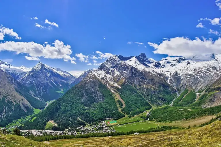
- The Valais is home to some of Switzerland’s most spectacular alpine nature. The canton holds several impressive mountain ranges with the country’s highest peaks. There are countless mountain valleys with gorgeous nature.
- It’s perfect for outdoor activities year-round. Apart from Zermatt and the Matterhorn, the Valais is mainly known as a winter sports area. But we think this wonderful canton is excellent for hiking, mountain biking, and more outdoor activities in other seasons too.
- There’s something for everyone: from bustling tourist centers (such as Verbier and Zermatt), to quaint valleys with remote villages (such as the Lötschental).
- The climate is generally sunny, and there’s less precipitation than on the northern side of the Swiss Alps.
Where to stay in the Valais
The Valais is a large region. So the best base town for you depends on your plans and interests. In general, these are the resorts we recommend:
- If you want to visit Lake Geneva and the canton of Vaud too, base yourself in or near Martigny. It’s centrally located: in the west of the Rhone Valley and just 35 minutes by train from Villeneuve on Lake Geneva.
- If you can’t choose from the many beautiful side valleys of the Valais, base yourself in a larger town down in the Rhone Valley. This way, you can make day trips to several mountain areas. Examples are Sion, Sierre/Siders, Visp, and Brig.
- If you want to make day trips to the Bernese Oberland, stay in or near Brig. You can travel north by the Lötschberg Mountain Railway or via the quicker Lötschberg Base Tunnel.
- If you want a winter sports holiday, stay in a high-altitude village. Some of our recommendations are Verbier, Zermatt, Saas-Fee, and the smaller towns in the Upper Rhone Valley. Consult our overview of winter resorts for further tips.
- If you want to be close to the Matterhorn, Zermatt or another town in the Matter Valley is the place to be.
- If you like panoramic views over the Rhone Valley and mountain ranges, base yourself on one of the south-facing villages on the northern slopes of the Rhone Valley. Examples are Anzère, Crans-Montana, Bettmeralp, Riederalp, and Fiescheralp.
- If you’re also interested in Andermatt and the mountain passes of Central Switzerland, base yourself in the Upper Rhone Valley: in Oberwald, or one of the other villages west of it.
What to expect in the Valais
What the Valais is famous for
Most visitors know the Valais from these highlights:
- The mountain resort Zermatt and the iconic mountain Matterhorn.
- The cogwheel train ride from Zermatt to Gornergrat.
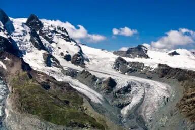
- The impressive Aletsch Glacier.
- The Glacier Express train ride between Zermatt in the Valais and St. Moritz in Graubünden.
- Switzerland’s highest mountain peak: the Dufourspitze at 4634 m.
But there’s much more to this large and very varied canton!
The Rhone Valley: the canton’s backbone
The river Rhone is the backbone of the Valais. It flows from the east of the canton, near Oberwald, to the west. There it enters Lake Geneva near Le Bouveret.
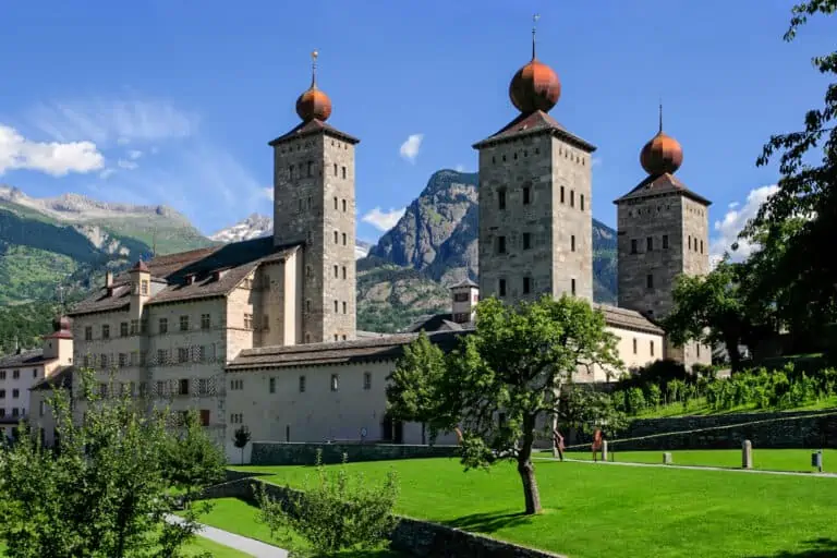
The western part of the Rhone Valley floor is wide and flat, and that’s where the larger towns and industrial and agricultural activity can be found. Examples are Brig, Visp and Sion. Each of these towns also has a lovely old town center.
The valley east of Brig is narrower, more V-shaped, and at a higher altitude. It’s called the Upper Rhone Valley. This is where nature is most beautiful and where smaller towns are located.
Rugged alpine nature and a sunny climate
When you travel from northern Switzerland to the south, for example via the Lötschberg train route, there’s a dramatic change in scenery. On average, the south is much dryer and rougher.
That’s typical for the Valais as well. There’s less precipitation and a lot of sunshine, especially in the lower, wider valleys. That’s where vineyards can be found.
Mountains of the Valais
The Valais is all about the Swiss Alps. There are several mountain regions. In the west is the area of Les Diablerets, bordering the canton of Vaud and the Lake Geneva region.
At the north are the Bernese Alps with the large Aletsch Glacier. This range marks the northern border of the Valais. The mountain area between the Kander Valley in the Bernese Oberland and Visp/Brig in the Valais is called “Lötschberg”. There are several side valleys of the Rhone Valley in these mountains, such as the pretty Lötschental (“Lötschen Valley”).
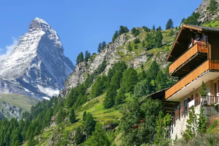
On the southern side, bordering Italy, are more mountain ranges. They contain some of Switzerland’s highest peaks, including the iconic Matterhorn. This is where the mountain resorts of Zermatt and Saas-Fee can be found.
In the east, the Valais borders the Alps of Central Switzerland. This is the area where many road passes are located: the Grimsel, Susten, and Furka Pass for example.
Reservoir lakes and irrigation channels
The Valais has no large lakes on which boat rides can be made, as in some other Swiss regions (Lake Geneva and Lake Lucerne for example). But there are beautiful mountain lakes, formed by glaciers and snow. There are quite some reservoir lakes too, such as the Lac d’Emosson west of Martigny and the Mattmarksee in the Saas Valley.
Farmers’ lands were, and still are, irrigated by open, wooden irrigation channels. Water flows down from the mountains into the pastures through these channels. They’re called “Suonen” in German and “bisses” in French. Many hiking trails in the Valais follow their tracks.
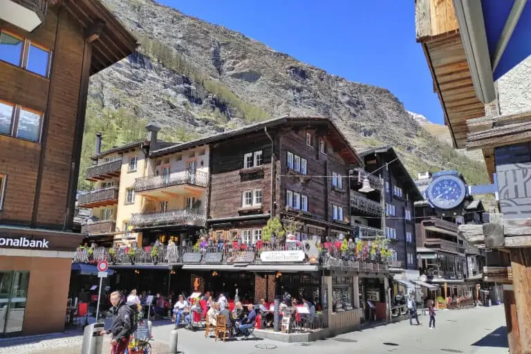
Authentic villages with wooden chalets
In many of the alpine areas of the Valais, you’ll find charming old Swiss villages. They’re full of chalets that are typical to this area: made from wood that’s sun-burned and darkened over the ages. Some chalets are built on stone pillars that are capped with stone discs.
If you’re lucky, these beautiful buildings will be snow-covered in winter. In summer, many of them are adorned with bright-colored flowers on the windowsills and balconies.
The sub-regions of the Valais
The western Rhone Valley between Martigny and Sierre
The western Rhone Valley is relatively broad and flat. The main towns here are Martigny, Sion, and Sierre (called “Siders” in German). There are wonderful mountain regions and side valleys on both sides of the Rhone Valley.
Examples on the southern side of the Rhone Valley:
- From Martigny, you can reach the reservoir lake called Lac d’Emosson and make trips to the Chamonix-Mont Blanc region in France.
- In the mountains east of Martigny, you’ll find the famous winter sports area Quatres Vallées (“Four Valleys”) with the town of Verbier.
- Other southern side valleys include those of the Grande Dixence reservoir lake, Evolène, and the beautiful Val d’Anniviers. Here are the mountain towns of Grimentz and Zinal, and the reservoir lake Lac de Moiry.
Examples on the northern side of the Rhone Valley:
- You’ll find the mountain region of Les Diablerets, which is also home to Glacier 3000.
- On the northern slopes of the valley are villages like Anzère and Crans-Montana, both well-known winter and outdoor sports resorts.
The mid of the Rhone Valley, between Sierre and Visp
Going further east, the Rhone Valley already gets a bit narrower. Visp is the next main town after Sierre/Siders. In between, there are smaller villages.
This area too has an abundance of pretty side valleys. Worth mentioning are:
- The valley of the famous spa resort Leukerbad.
- The wonderful Lötschental (“Lötschen Valley”) with its authentic villages. It’s a hikers’ paradise.
- The wild Turtmanntal (“Turtmann Valley”).
The eastern Upper Rhone Valley, between Visp and Oberwald
The Rhone Valley itself is prettiest in eastern Valais. This part is called “Goms” in German. In English, it’s mostly referred to as the Upper Rhone Valley. The main larger town in the Upper Rhone Valley is Brig. Further east, there are smaller villages like Fiesch, Münster-Geschinen, Ulrichen, and Oberwald.
Famous resorts on the northern mountain slopes of the Rhone Valley are Bettmeralp, Riederalp, and Fiescheralp. These villages lead to vantage points such as Bettmerhorn and Eggishorn, where you’ll find amazing views of the Aletsch Glacier. Bellwald is another very pretty mountain village.
The Binntal (“Binn Valley”) southeast of Fiesch is worth your attention. It’s a beautiful hiking area, and many valuable gems are found here.
The east of the Upper Rhone Valley provides access to the Furka Pass and the Oberalp Pass, connecting the Upper Rhone Valley with the cantons of Uri and Graubünden. Another major pass road is the Grimsel Pass, leading to Innertkirchen and Meiringen in the Bernese Oberland.
The Matter Valley and the Saas Valley
South of Visp in the Upper Rhone Valley, and bordering Italy, is the Matter Valley. It’s very popular. This goes especially for its southern end, where Zermatt and the Matterhorn are located.
Next to the Matter Valley is the Saas Valley, with another famous resort: Saas-Fee. Lots of winter sports and hiking options are available here.
Other websites of interest
- www.pfyn-finges.ch: regional nature park Pfyn-Finges
- www.valais.ch: hikes along open irrigation channels
- www.martigny.ch: Martigny Tourism
- www.verbier.ch: Quatres Vallées and Verbier Tourism
- www.visit-grande-dixence.ch: the Grande Dixence Dam
- www.evolene-region.ch: Evolène Tourism
- www.anzere.ch: Anzère Tourism
- www.crans-montana.ch: Crans-Montana Tourism
- www.leukerbad.ch: Leukerbad Tourism
- www.loetschental.ch: Lötschental Tourism
- www.turtmanntal.ch: Turtmanntal Tourism
- www.goms.ch: Goms / Upper Rhone Valley Tourism
- www.binntal.ch: Binntal Tourism
More about the towns of the Valais
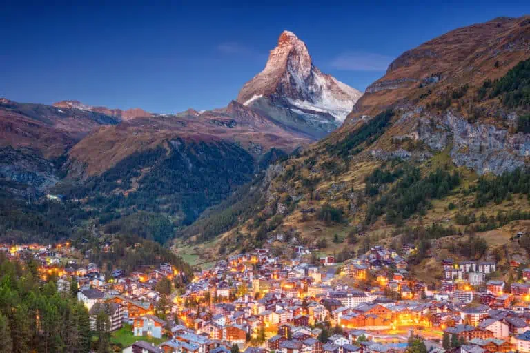
Zermatt
Saas-Fee
Itineraries that include the Valais
Glacier Express: 3-day classic tour from Zurich
Glacier Express: 4-day slow-paced tour from Zurich
Ultimate scenic trains
The Valais in our blog posts
Gornergrat, Matterhorn Glacier Paradise, Sunnegga-Rothorn
Hike Täsch-Zermatt